Ecology Camp Trail Guide
Even though we weren't able to hold our Ecology Camp for Summer 2020, you can take part in some of the activities yourself! Check out this trail guide to some of our favorite destinations! Even though none of these hikes are particularly technical, always be sure to bring a backpack with your cell phone, a good map, water, and a first aid kit.
Shingletown Gap

Singletown Gap is one of the most beloved locations near State College for hiking. Only a few miles from downtown and visible across the valley from Penn State's campus, it makes for a convenient evening hike.
Driving Directions: Take PA 45 west from Boalsburg. After approximately 2 miles you'll spot Mountain Road on the left (near the bottom of the dip where PA 45 crosses Roaring Run). Take Mountain Road for approximately a mile to the conspicuous parking area on the left side- there is a large gate and several boulders. (This parking area can sometimes fill up on busy weekends.) GPS: 40.754002, -77.818049

Additional Maps & Resources:
DCNR Rothrock State Forest Map (Includes all trails to the south and east of Shingletown Gap, but not the trail described above.)
PA Hikes has many trail maps of Shingletown Gap. You could spend weeks exploring them all!
Fisherman's Paradise at Spring Creek Canyon
Ecology Camp spends two days exploring locations on the Spring Creek Canyon. This location is particularly special for fisherman who travel from across the globe to fly fish in the canyon. A combination of cold, spring-fed waters, clean water due to an impressive conservation effort from many different organizations in the Centre region, and limestone bedrock help make a perfect environment for several species of trout. You can often spot them just by peering over the bank behind logs and boulders in the stream where they like to congregate.
Driving Directions: From State College, take I-99 Northbound towards Bellefonte. Take exit 78B (150 N) toward Bellefonte. Merge onto Benner Pike and take a left at the first light (Fisherman's Paradise.) The descent into the canyon is steep and curvy- be careful! At the bottom of the canyon, turn left at the stop sign and continue until the road ends in a gravel parking lot. GPS: 40.879824, -77.792468
Trail Description: The trail is flat and graveled- perfect for biking! (Through a combination of trails and some roads, you can actually make it the entire way from Bellefonte to the Arboretum through Spring Creek Canyon!) About a quarter mile in, you'll find one of the steepest and tallest natural cliffs in Central PA. You can spot small caves, remnants of ancient stalactites, and ancient fossils in the Ordovician-era limestone. You won't see any fish fossils, though, because they hadn't even evolved yet! 450 million years ago, this limestone actually started as a reef similar to what you'd see now in the Florida Keys!
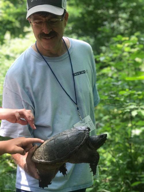
About a mile in, you'll find several old ponds no longer used by the Fish & Boat Commission in their hatcheries. Sometimes eagles, herons, and ospreys can be found in the trees lining these ponds! Several years ago, a camper also spotted the largest snapping turtle many of us had ever seen lurking in the muck.
We do not recommend straying too far from the gravel trail. The brush is quite thick and infested with ticks. Two of our staff members can personally vouch for this.
Additional Maps & Resources:
The PA Fish & Boat Commission has a great map of the canyon!
Scotia Barrens

The Scotia Barrens is one of the stranger places in Centre County. Several ghost towns are in the area, remnants of long-gone iron ore operations. This walk will take you to 10-acre pond, a spot we love to visit and look for aquatic macroinvertebrates and amphibians. This is in State Game Lands 176, so visit outside of hunting season!
Driving Directions: From State College, take I-99 south towards Altoona. Take exit 68 (Grays Woods/Waddle). Follow the signs to Grays Woods, then turn left just before Geisinger onto Scotia Road. Take another left onto Scotia Range Road. After 0.6 miles, you'll see a parking area on the left. GPS: 40.800859, -77.945421
Trail Description: This trail is actually an old railroad track used during the iron ore era (late 1800s-early 1900s). You'll likely spot lots of heavy, reddish-brown "gravel" on the tracks that feels heavier than it looks- that's iron ore! Follow the tracks to the left and you'll see 10-acre pond. This year, it's simply a field, but last year it was over 6 feet deep! Somehow many of the amphibians survive each year, perhaps burrowing into the mud to wait out droughts. Several trails circle the ponds, but no good maps of them exist, so don't go too far!
Additional Maps & Resources:
No easily accessible trail maps of the area exist, so don't stray too far! A road map is available from the PA Game Commission.
Learn about the history of the area from Uncovering PA.
Black Moshannon State Park

Black Moshannon (or "Black Mo") is one of the true gems of Central Pennsylvania. Hiking, biking, boating, camping, ice cream eating- this park has everything. From the short, easy "lake loop" trail at the swimming area to the massive, multi-day, boot-destroying, 39-mile Allegheny Front Trail, outdoor enthusiasts can find activities for any skill level. For this hike, we'll be able to see one of the coolest vistas in Central PA!
Driving Directions: From State College, take I-99 South to Exit 68/Waddle. Follow the signs for Waddle, including a hard right turn just after the road cut. Turn right onto PA 550, then quickly turn left onto Julian Pike. Follow this road over Bald Eagle Mountain, through Julian, across US-220, and onto Beaver Road. This will take you up the Allegheny Front, the dividing line between the Ridge and Valley province and the rugged Allegheny Plateau. At the top of the mountain, turn right onto Underwood Road- you'll see a very large gravel pad at the intersection to mark the right road. Travel approximately 1.4 miles on Underwood Road, keeping a sharp eye out for the wooden 4x4 post marking the Allegheny Front Trail. Park in the small clearing to the left. GPS: 40.893375, -78.001657
Trail Description: Walk uphill from your car (the right side of the road as you drove in). The trail is fairly smooth, easy, and shallowly inclined for the first mile or so. At the top of the Allegheny Front, there is a short 10-foot cliff that requires some "creative" maneuvering around large boulders. Note how some of the trees are growing direction on top of the massive boulders! Just like Shingletown Gap, the rock here is sandstone. (You'll see this trend often in Central PA- the reason we have ridges is due to some complex geology, but basically sandstone is hard to erode, while limestone and shale are easy. Therefore, the sandstone gets left behind and forms mountains like the Allegheny Front and Tussey Mountain, while the limestone dissolves easily to make Spring Creek Canyon.) The trail levels out again and eventually comes to two beautiful vistas- "Ralph's Majestic Vista" and the modestly-named "Ralph's Pretty Good View". Both are named after Ralph Seeley, local history legend and the founder of the Allegheny Front Trail.
Additional Maps & Resources: DCNR has a great map of the entire Allegheny Front Trail.
Do you have a favorite Central PA trail we should include? Send us some info at outreach@science.psu.edu!